RBSE Class 12 Geography Board Paper 2018 English Medium are part of RBSE Class 12 Geography Board Model Papers. Here we have given Rajasthan RBSE Class 12 Geography Board Paper 2018 English Medium.
| Board | RBSE |
| Textbook | SIERT, Rajasthan |
| Class | Class 12 |
| Subject | Geography |
| Paper Set | Board Paper 2018 |
| Category | RBSE Model Papers |
Rajasthan RBSE Class 12 Geography Board Paper 2018 English Medium
Time: 3.15 Hours
Maximum Marks: 56
General Instructions to the Examinees
- Candidates must write first his/her Roll No. on the question paper compulsorily.
- All the questions are compulsory.
- Write the answer to each question in the given answer-book only.
- For questions having more than one part, the answers to those parts are to be written together in
continuity. -
Section Q. Nos. Marks per Question Word Limit of Answer A 1 – 13 1 20 words B 14 – 21 2 60 words C 25 – 27 3 100 words D 28 – 30 4 250 words - Question Nos. 22 to 24 are related to map-work carrying 2 marks each.
- Attach outline map of World, India and Rajasthan with the answer-book.
- There are internal choices in Question No. 29 & 30.
SECTION – A
Question 1.
Which geographer wrote the book “Anthropo – Geography? [1]
Question 2.
What percentage of world population is found in the northern hemisphere? [1]
![]()
Question 3.
Where is a composite rural settlement found in Kota district of Rajasthan? [1]
Question 4.
Which cities are situated on both the ends of Trans – Siberian rail route? [1]
Question 5.
What is the rank of India in the world in sheep – rearing? [1]
Question 6.
In which year Planning Commission was constituted in India? [1]
Question 7.
Why is the entry of three-wheelers restricted in Dharavi? [1]
Question 8.
Differentiate between transport and communication. [1]
Question 9.
Why biotic resources are generally non-exhaustible? [1]
Question 10.
Write any two reasons for the necessity of planning in India. [1]
![]()
Question 11.
Why is Rajasthan called “Museum of Minerals”? [1]
Question 12.
Which branch of geography will you select for making strategy of population and resources of regions? [1]
Question 13.
Suggest a suitable medium/means of transport for rapid relief in natural disasters. [1]
SECTION – B
Question 14.
What is secondary occupation? Write any two examples. [2]
Question 15.
Write any four factors affecting literacy rate. [2]
Question 16.
How does Bushman hunt big animals? (any two ways) [2]
Question 17.
Write any four reasons for high population density in western and central Europe. [2]
![]()
Question 18.
Import and export of India for the period of April – December 2015 was respectively 351.61 and 239.93 billion dollars. Clarify the condition of Indian trade balance and give suitable suggestion in the interest of the nation. [2]
Question 19.
Suggest any two measures related with use of fuel to control air pollution. [2]
Question 20.
Suggest any two measures for sustainable development. [2]
Question 21.
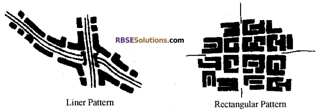
Draw sketches for linear and rectangular patterns of rural settlements. [2]
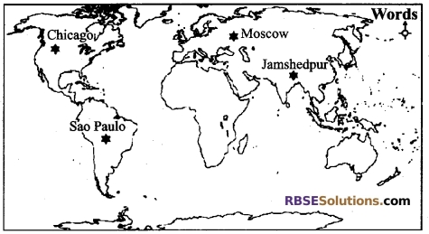
Question 22.
Mark the location of major iron and steel centres in the given outline map of the World. [2]
1. Chicago
2. Moscow
3. Sao Paulo
4. Jamshedpur
Question 23.
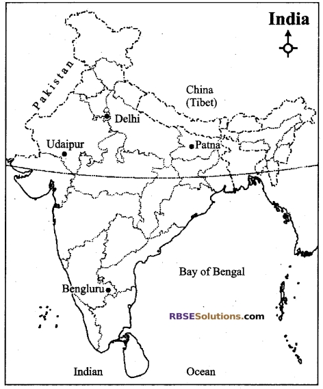
Mark the location of the major airports in the given outline map of India: [2]
1. Delhi
2. Udaipur
3. Bengaluru
4. Patna
![]()
Question 24.
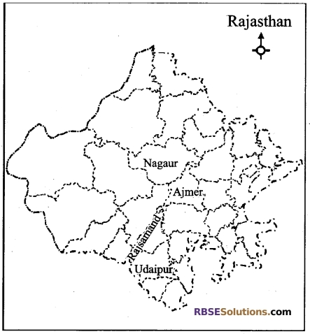
Mark the location of the major marble producing districts on the outline map of Rajasthan: [2]
1. Udaipur
2. Ajmer
3. Rajsamand
4. Nagaur
SECTION – C
Question 25.
Explain the spatial patterns of population growth in India. [3]
Question 26.
Suggest any six measures to solve the population problem of the world. [3]
Question 27.
Suggest any three measures for management and conservation of water and describe them. [3]
SECTION – D
Question 28.
Why animal rearing is practiced? Compare the Nomadic Herding with commercial livestock rearing under the following heads: [4]
1. Characteristics
2. Area
![]()
Question 29.
Describe Wheat or Rice cultivation in India under the following heads: [4]
1. Important geographical conditions
2. Production and distribution
OR
Description of cultivation of rice
Question 30.
Compare the Bhil and Mina tribes under the following heads- [4]
1. Area
2. Social Life
3. Economy
OR
Why the surface water resource is important in Rajasthan? Explain the three stages of Mahi Bajaj Sagar project.
Answers
Answer 1:
Friedrich Ratzel.
Answer 2:
85 per cent.
Answer 3:
In village Khurd of tehsil Sangod.
Answer 4:
Leningrad (Saint Petersburg) on the western end and Vladivostok on the eastern end.
Answer 5:
Second.
![]()
Answer 6:
In the year 1950.
Answer 7:
Streets and alleys are so narrow here that it is difficult even for a cycle to pass through, therefore, entry of three-wheelers is restricted in Dharavi.
Answer 8:
Carrying people or goods from one place to another or traveling through a physical means is known as transport. Spatial exchange of messages, thoughts, etc. is known as communication.
Answer 9:
As all the biotic resources are renewable by propagating due to their reproductive capacity, they are generally non-exhaustible.
Answer 10:
- For increase in national and per capita income.
- For all-around development of the country.
Answer 11:
Rajasthan is a prosperous state with the point of view of minerals. Due to the availability of various types of minerals in Rajasthan, it is called the Museum of Minerals.
![]()
Answer 12:
Human Geography.
Answer 13:
Air transport.
Answer 14:
Those occupations done by man under which the resources provided by nature are not directly used, rather they are refined and transformed to make them more useful and precious, i.e. not using the resources provided by nature directly and making them usable by refining and transforming them through human activities are known as secondary occupation. Examples of secondary occupation-
- Making cotton clothes from cotton and
- Making furniture and paper from wood and wood pulp.
Answer 15:
Following are the factors affecting literacy rate: (write any four)
- Level of economic development,
- Urbanization,
- Standard of living of people,
- Social condition of women,
- Level of facilities and
- Government policies.
![]()
Answer 16:
Bushman adopts the following ways to hunt big animals: (write any two)
- By compelling the animal to become helpless in sludge.
- By catching the animal in the trap or snare.
- By compelling the animal to fell in the trench.
Answer 17:
Following are the reasons for high population density in western and central Europe- (write any four)
- Availability of healthy climate.
- Presence of levelled plain regions.
- Availability of fertile soil.
- Industrial development.
- Presence of mineral wealth.
- Availability of water in abundance.
Answer 18:
Condition of Trade Balance of India- It is clear from the data related to import-export of India that during this period (in April – December), the trade deficit was 111.68 billion dollars.
Suitable suggestions in interest of the nation:
- Encouragement to export in place of import.
- Encouragement to the use of non-conventional sources of energy to reduce oil exports.
- Increase should be done in production and optimum utilization of resources should be done.
Answer 19:
- Priority should be given to the use of solar energy, electric energy, wind energy, battery-operated vehicles and equipments in place of petrol and diesel.
- Gas stoves should be used.
![]()
Answer 20:
- Eco-friendly technology should be developed and used for development and increase in production.
- Environmental conservation and decentralization of increase in production should be done.
- There should be an appropriate standard of environmental protection, ecological balance and economic efficiency, (write any two).
Answer 21:
Answer 22:
Answer 23:
Answer 24:
Answer 25:
Spatial pattern of population growth in India is full of diversities. Decline has been recorded in almost all the states and union territories in 2001-2011 as compared to 1991- 2001.
Decline has been recorded in the percentage of decadal growth rate during 2001 – 2011 in Uttar Pradesh, Maharashtra, Bihar, West Bengal, Andhra Pradesh and Madhya Pradesh. Greatest decline has been recorded in Nagaland (65%) while increase has been recorded in Tamil Nadu and Pondicherry. Spatial distribution of growth rate has been divided into the following groups:
- Regions of extreme population growth: These include those states where growth rate has been more than 30% during this period. Dadra and Nagar Haveli are mainly included in these.
- Regions of medium population growth: These include those states of India where the growth rate has been between 20% – 30%. Bihar, Jammu – Kashmir, Jharkhand, Madhya Pradesh, Meghalaya, Rajasthan, Uttar Pradesh, Delhi and Pondicherry are included in these regions.
- Regions of moderate population growth: These include those regions where the growth rate has been less than 20%. Andhra Pradesh, Assam, Goa, Gujarat, Haryana, Himachal Pradesh, Karnataka, Kerala, Maharashtra, Manipur, Nagaland, Orissa, Punjab, Sikkim, Tamil Nadu, Tripura, Uttarakhand, West Bengal, Andaman and Nicobar group of islands, Chandigarh and Lakshadweep are included in this.
![]()
Answer 26:
- Restructuring of agriculture should be done.
- Encouragement should be provided to the use of oceanic resources.
- Increase in economic production should be done through optimum utilization of physical resources.
- Awareness should be created towards spread of education and maximum propagation of science and technical training.
- Population should migrate towards sparsely populated regions.
- Late marriages, family planning and birth control should be adopted.
Answer 27:
Following are the three measures for management and conservation of water-
1. Eradication of water pollution: Due to increasing human activities, quality of water resources is rapidly declining. In order to prevent water pollution and decline in the quality of water, organic manure and insecticides should be largely used in place of chemical fertilizers and insecticides. Along with this, polluted water should be refined through modem techniques and be used in agricultural works and it is also essential to use the polluted water from industries in by-productive activities.
2. Recycle and Reuse of water: Availability of non-saline water and water quality can be improved by the use of modem technique of recycle and reuse of water. Along with this, refined waste water of low quality can be used in refrigeration and fire extinguishers, bathing, washing utensils and in washing vehicles etc.
3. Rainwater harvesting: The process of holding and collecting rainwater for various uses is known as rainwater harvesting. This method is used for recharging underground water resources. Under this method, rainwater is collected in man-made underground tanks along with pits, ponds and wells etc. Through these efforts, there is increase in underground water level. In traditional form, rainwater has been collected in India in lakes, ponds, pools and tanks.
![]()
Answer 28:
Reasons for practicing animal rearing- The major objective of man behind animal rearing is to obtain food material (milk, curd, buttermilk, butter, cheese and various milk products), meat, hide, wool and to use the animals for loading and transporting goods for place to place.
Comparison between Nomadic Herding and Commercial Livestock Rearing:
Basis of Difference
| 1. Characteristics | Nomadic Herding | Nomadic Herding |
| These wander from place to place in search of fodder and water. Animals are reared in a natural manner and no special care of them is taken. Nomadic herding is an economic activity for life subsistence. This is limited to the old-world. No special attention is provided to reproduction, breed improvement, control upon diseases and health of the animals. |
These wander from place to place in search of fodder and water. Animals are reared in a natural manner and no special care of them is taken. Nomadic herding is an economic activity for life subsistence. This is limited to the old-world. No special attention is provided to reproduction, breed improvement, control upon diseases and health of the animals. |
|
| 2. Region/area | This occupation is mainly practiced in Sahara Desert, desert region of Western Asia, Mongolia, Central China, mountainous regions of Tibet and Andies, Tundra Region of Eurasia, south-western Africa and Madagascar Island. | This occupation is mainly practiced in Sahara Desert, desert region of Western Asia, Mongolia, Central China, mountainous regions of Tibet and Andies, Tundra Region of Eurasia, south-western Africa and Madagascar Island. |
Answer 29:
Important Geographical Conditions: Following are the important geographical conditions required for the cultivation of wheat:
- Temperature: Wheat is mainly a temperate crop. While sowing wheat, 10° C, while growing, 15°C and while ripening and harvesting, 20° C – 28° C temperature is required.
- Rainfall: 50 cm to 75 cm rainfall is required for the cultivation of wheat. Excess of rainfall is harmful for its cultivation. But irrigation is needed in case of less rainfall.
- Soil: Wheat can be cultivated in a variety of soils. But, loamy, sandy loamy and black soil is more suitable for its cultivation.
- Land: For the cultivation of wheat, the land should be leveled and it should have a proper drainage system.
- Labour: More labour is required for the cultivation of wheat, but increasing mechanization in agriculture has decreased the importance of manual labour.
![]()
Production and Distribution
Almost 12% wheat of the world is produced in India. Due to being a temperate crop, it is produced in India in the form of a Rabi crop during the winter season. Due to being a Rabi crop, cultivation of wheat is mainly done in those regions which have appropriate irrigation facilities. But in high mountainous regions of the Himalayas and in Malwa Plateau regions of Madhya Pradesh, cultivation of wheat fully depends upon the monsoon.
Major Wheat Producing Regions of India- In India, with the viewpoint of wheat production, the plains of Sutlej, Yamuna and Upper Ganga are the most important. Around 68% of total wheat of India is produced in this region. Major wheat producing states of India and their regions are briefly described below-
Uttar Pradesh: This is the leading wheat producing state of India. In this state, Ganga-Yamuna, Ganga-Ghaghara Doab region is especially renowned for the cultivation of wheat, where 75% wheat of the state is grown. Major wheat producing districts of this state are Saharanpur, Muzaffarnagar, Meerut, Moradabad, Rampur, Budaun, Bulandshahar, etc. Record 25.2 million tonnes of wheat was produced in Uttar Pradesh in the year 2014-15.
Punjab: This is the second largest wheat producing state. Due to the impact of the Green Revolution, there has been a significant increase in the production of wheat in Punjab. Here, wheat is cultivated on 30 per cent part of the total agricultural land. Due to irrigation facilities, fertile soil and use of advanced manure and seeds, the average yield in the state is 5017 kg per hectare, which is the largest in the country. In 2014 -15,15.8 million tonnes of wheat was produced in the state. Its major wheat producing districts include- Ludhiana, Jalandhar, Amritsar, Kapurthala, Firozpur, Bhatinda, Patiala and Sangrur.
Haryana: It is small with the point of view of surface area but due to irrigation facilities it has become a major wheat producing state with around 13.5 per cent wheat being produced here. Here, the country’s 8 per cent wheat producing regions are located in Rohtak, Hissar, Jind, Kurukshetra, Sirsa, Fatehabad, Ambala, Gurgaon and Faridabad.
Madhya Pradesh: Wheat is produced through irrigation in plain regions and in black soil regions of Malwa. In the year 2014 -15,14.2 million tonnes of wheat was produced in the state. Madhya Pradesh is the third largest wheat producing state of the country. Guna, Bhind, Gwalior, Ujjain, Sagar, Indore, Jabalpur, etc. are its major districts of production.
Rajasthan: In this state, due to scarcity of rainfall, wheat crop is cultivated through irrigation. Wheat is cultivated on 18 per cent part of the total agricultural land in the state. After the construction of the Indira Gandhi canal, yield of wheat has increased in Rajasthan. Here, 7 – 9 per cent wheat of the entire country is produced. Its major wheat producing districts are Sri Ganganagar, Bharatpur, Alwar, Baran, Jaipur, Bhilwara, Sawai Madhopur, Banswara, etc.
![]()
OR
Following is the description of required geographical conditions for the cultivation of rice and its production and distribution:
Essential geographical conditions: Rice is a tropical crop. There are more than 3000 varieties of rice which are grown in different agro-climatic zones. Following are the required geographical conditions for its cultivation:
- Temperature: A minimum temperature of 20°C is required for the cultivation of rice. 20°C temperature is required at the time of sowing and 27°C temperature is required at the time of ripening of the crop.
- Rainfall: Excessive water is required for the cultivation of rice. Normally, it is cultivated in regions receiving 100 to 200 cm rainfall. Rice is cultivatied with the help of irrigation in regions having less than 100 cm rainfall.
- Soil: Very fertile soil is required for the cultivation of rice. Clayey loamy soil is ideal for its cultivation because this soil can retain moisture for longer time period. The plant of rice grows well in alluvial soil brought by the rivers.
- Land: Leveled plain regions are suitable for the cultivation of rice, so that water received by rainfall or irrigation may remain in the fields for the required time. In hilly regions, rice cultivation is done by forming terraced fields on slopes.
- Labour: Machines cannot be fully applied in the cultivation of rice, therefore more labour is required for its cultivation.
Production and Distribution: In India, rice is successfully cultivated in regions having a height of 200 m above sea level, in arid regions of eastern India and in arid and irrigated regions of north-western India which include Punjab, western Uttar Pradesh and northern Rajasthan.
In India, in 2015 – 16,103.36 million tonnes of rice was produced which was 40.97 per cent of the total food grain production.
Percentage of rice production in various states of India is as follows-
1. West Bengal: 14 per cent rice producing region of the country is present here. On the basis of 2014 -15, it is at the first place with 14.32% rice production. Major producing districts include: Cooch Behar, Jalpaiguri, Bankura, Midnapur and Darjeeling. Here, all the three crops- Os, Aman and Bori are grown. Due to the fertile soil of floods, there is less requirement of manure.
2. Uttar Pradesh: After the Green Revolution, there was a significant increase in rice production here. Here, rice production has increased to 12% of the total production of the country. Major producing districts include- Saharanpur, Deoria, Gorakhpur, Lucknow, Bahraich, Gonda, Ballia, Raebareli, Pilibhit, etc. 12.2 metric tonnes of rice was produced in 2014 -15, which was 11.7% of the country’s total rice production.
3. Andhra Pradesh: On the basis of production in 2014 -15, this state was at the third place in the country by producing 11 per cent rice.
4. Punjab: Traditionally being a wheat producing state, Punjab has recorded the highest increase in rice production in the country after the Green Revolution. In the year 2011 -12, around 108.3 lakh tonnes of rice was produced in Punjab, which was 11.29 per cent of the total rice produced in the country. Major rice producing districts of this state include- Hoshiarpur, Gurdaspur, Jalandhar, Amritsar, Rupnagar, Ludhiana, Kapurthala, etc. According to 2014 -15, this state is at the first place by producing 3952 kg rice per hectare.
5. Bihar: Two crops of rice are obtained in a year in this state. Rice is grown on 40 per cent of total agricultural land in this state. Major rice producing districts include- Saran, Champaran, Gaya, Darbhanga, Munger, Pumia, etc.
6. Tamil Nadu: This state has a share of 6 -10 per cent in the total rice production of the country. Here, Thanjavur district situated in the Kaveri River Delta alone produces 25 per cent rice of the entire Tamil Nadu.
7. Chhattisgarh: Plain region of Chhattisgarh is significant in context to rice cultivation and it is usually known as the Rice Bowl. Bilaspur, Bastar, Surguja, Raigarh, Dantewada, Narayanpur, etc. are the major rice producing districts.
8. Odisha: Rice is produced on 58 per cent part of the total agricultural land in this state. This state produces 6 to 8 per cent of total rice produced in India. Balasore, Cuttack, Puri, Mayurbhanj, Kalahandi, etc, are the major rice producing districts. Central Rice Research Institute is situated in Cuttack.
9. Rajasthan: Rice is cultivated in Dungarpur, Bundi, Banswara, Hanumangarh and Sri Ganganagar districts in Rajasthan.
Maharashtra, Karnataka, Assam, Kerala, Meghalaya, Goa, Manipur, Nagaland and Mizoram are other rice producing states.
![]()
Answer 30:
Comparison of Bhil and Mina Tribes:
Bhil Tribe
1. Area: Bhil tribal people usually reside in Banswara, Dungarpur and Udaipur districts of southern Rajasthan. The habitat regions of these people are rugged and forested areas. They reside in the hills in scattered form.
2. Social Life: Bhil tribal people are socially patriarchal, farmers in economic form and are traditionally bowmen.
Following are the major characteristics of their social life:
- Their social system is patriarchal. Bhil tribal people have various patriarchal clans, which are
called as “Atak”. ‘ - Morbadia marriages, kidnap marriages, exchange marriages, service marriages, etc. are prevalent in Bhil tribal people.
- Nuclear families are mainly found in Bhil tribal people.
- In the administration of the villages of Bhil tribal people, Bhopa (those who perform exorcism), Head (Gomti) and those who conduct religious rituals (Bhagat) play important roles.
- Baneshwar Fair, a famous fair of the Bhil tribal people, is organized on Magh Shukla Purnima on the confluence of rivers Mahi, Som and Jakham.
- Dance during festivals and worship during ceremonies is a major social tradition of Bhil tribal people.
- Bhil men and women wear metallic ornaments and they also make tattoos on their skin.
- Along with Hindu gods and goddesses, worship of local folk deities is a component of their social life.
3. Economy: With economic point of view, Bhil tribal people are poor and vagabonds by nature. Basically, these people are farmers. Fishing is also an important occupation of these people. Hunting birds, and collecting medicinal herbs, bulbs roots, fruit, gum, berries, mahua, custard apples, wood, etc. from the forests is their major occupation.
Along with agriculture, animal husbandry is also a major occupation of the Bhil tribal people. At present time, most of the Bhil people are performing labour in nearby cities and towns.
Mina Tribe
1. Area: Mina tribe is found in almost all the regions of Rajasthan. They are found in maximum number in Jaipur, Dausa, Sawai Madhopur, Karauli, Alwar, Tonk, Bharatpur and Udaipur districts. Mina tribal people have their historical habitat in Alwar, Bharatpur and Jaipur districts. This region was known as Matsya Pradesh. Most of the population of Mina tribal people is in Jaipur district. Mina tribe is regarded as the most educated tribe.
2. Social Life: Following are the major characteristics of social life of Mina tribe:
- Marital relationships, kinship and blood relationships are considered significant in Mina tribe.
- Mina tribal girls are married at a younger age, but ‘gaunaa’ takes place in the appropriate age of marriage. –
- Joint family system is prevalent in them and patriarchal families are found.
- Panchayats have a significant place in social life of Mina tribal people. Social disputes, marriage, divorce, disputes associated with character, etc. are resolved by the panchayats.
- Mina tribal people have immense faith in religious fairs and festivals.
- Mina men wear dhoti and shirt, while Mina women wear Ghaghara, choli and orhni.
- Spread of education has been rapid in this tribe. They have derived the maximum benefit from reservation system.
3. Economy: Mina tribal people mainly perform the task of farming. Along with this, animal husbandry is also an important occupation of Mina tribal people. Sharecropping agricultural practice is prevalent among them. Among all the tribes, Mina tribe is the most educated tribe of Rajasthan. Mina tribal people are found posted in government services and other businesses.
At present, due to reservation system in government services, the socio-economic condition of the Mina tribal people is found to be better as compared to other communities.
![]()
OR
Importance of Surface Water in Rajasthan: With geographical point of view, Rajasthan is the largest state of India. Rajasthan receives minimal rainfall in the entire country. Along with this, Rajasthan has to face the plight of drought every now and then. Severe problem has to be faced in providing potable water in the desert regions of Rajasthan. This scarcity of water present in Rajasthan is fulfilled by rivers, ponds and lakes. Due to this, surface water is of utmost importance in Rajasthan.
Three Phases of Mahi Bajaj Sagar Project-
- First Phase: In this phase, Mahi Bajaj Sagar dam was built on river Mahi in Borkhera village near Banswara. Its water catchment area is 524 sq. km. Its wadding capacity is 12.10 T.M.C.
- Second Phase: Two canals named Anandpuri and Sagwara have been carved out to provide the facility of irrigation in Dungarpur district. Total length of these distributaries is 854 km. There is a proposal of providing irrigation facility in 1.23 lakh hectare of land through this project.
- Third Phase: Two powerhouses have been built under this phase. 140.95 MW hydroelectricity is being produced by this project.
We hope the given RBSE Class 12 Geography Board Paper 2018 English Medium will help you. If you have any query regarding Rajasthan RBSE Class 12 Geography Board Paper 2018 English Medium, drop a comment below and we will get back to you at the earliest.