Rajasthan Board RBSE Class 9 Social Science Notes Chapter 12 Physical Features of India
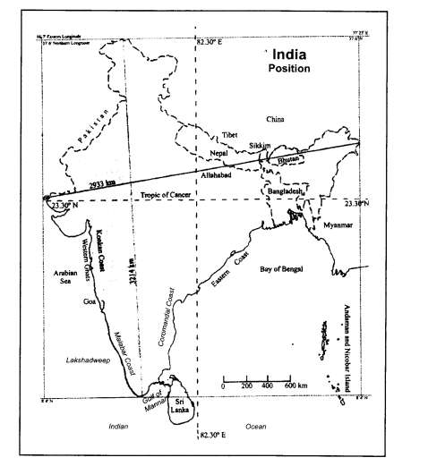
Geographical Extension
- Location: India sub-continent is located in the Northern and Eastern Hemisphere.
- Shape: Quadrangular
- Extension: India measures about 3,214 km from north to south and about 2,933 km from east to west. .
- Area: 32,87,263 sq. km, ranks 7th largest in the world occupying for about 2.4% of the total area.
- Landline boundary: 15,200 km.
- Coastal boundary: 7,516.6 km.
- The latitudinal exent is between 8°4‘ N to 36°6’N. Tropic of Cancer (23°30′) passes through the center of India dividing into two climatic zones – tropic zone in south and warm temperature zone in north.
- The longitudinal extent is between 68°7′ E to 97°25’E. The longitude of 821/2°E passes midway through India, near Allahabad and helps in fixing uniform time for the country. Hence, it is rightly called the Standard Meridian of India.
Neighbouring Countries
- India’s neighboring countries are seven, i.e., Bangladesh, China, Pakistan, Nepal, Myanmar, Bhutan and Afghanistan. Pakistan and Afghanistan in north-west, Bangladesh and Myanmar in the east, China, Nepal and Bhutan in north. In the south, on the eastern side, the Gulf of Manner and a narrow channel of water called Palk Strait separated India from Sri Lanka.
- India shares largest boundary with Bangladesh (4096 km), followed by China (3488 km), Pakistan (3323 km), Nepal (1751 km), Myanmar (1643 km), Bhutan (699 km) and Afghanistan (106 km).
- Indian Standard Time (1ST) is half an hour behind of Bangladesh Standard Time and half an hour ahead of Pakistan Standard Time.
Physical Divisions of India
It can be divided into five main divisions:
- The Northern Mountain Region
- The Northern Vast Plains
- The Thar Desert
- The Peninsular Plateau
- The Great Indian Desert
- The Coastal Plains
The Northern Mountains
In the north of India, 2500 km from West to East, varying width from 250 to 400 km, height about 6000 mts and in about 5 lakh sq km area. The Himalayan range, part of Pamir mountain system, originate from Pamir knot extending upto Arunachal Pradesh. The Himalayan ranges had their origin in the Tethys sea, due to movement in tectonic plates its bottom elevated resulting into formation of new yoiing fold mountains.
Four parallel ranges of this region
- The Greater Himalayas also called Himadari, comprises Main Himalaya, Inner Himalaya or frozen Himalaya.
Its main features: Extension from the gorge of the Indus in North-West to Brahmaputra in East.
Average Height: 6000 mts, Width-100-200 km. The highest peak of the world is Mount Everest (8848 mt high) located here. Other peaks are Nanda Devi, Kanchenjungha (8585 m) Godwin Austin, Nanga Parbat, etc.
Passes: Jogila, Shipki, Mana, NITI, etc.
Source of origin– Ganga and Yamuna rivers.
The Lesser Himalayas parallel to the south of the Greater Himalayas. Height: 3000-5000 mts; width 80 to 100 kms.
Ranges: Pirpanjal and Dhauladhar. Passes: Banihal is the main pass Coniferous forests on higher parts and grasslands on lower parts.
Hill stations– Mussoorie, Nainital, Shimla, Darjeeling, etc.
- The sub-Himalayas or Outer Himalayas, Shiwalik at the foothills of the Himalayas. Average Height– 600 to 1500 mt, Width– 10 to 50 km.
Duns separate it from the lesser Himalayas in the West and Dwars in the East. - The trans-Himalayas to the North of Great Himalayas.
Total length– 965 km, Average Height- 3100 to 3700 mt, Width– 40 km.
Ranges– Kailash and Karakoram Peaks- K2, etc.
Glaciers– Siachin, Hispar, Baltaro, etc.
Sidney Burrad has divided Himalayas on the regional basis.
The Northern Plains
The Northern Plains are the home of millions of people and support agriculture. These are extensive low-lying flat areas, with low slope formed by constant deposition of fine rock materials (silt) by Indus, Ganga and Brahmaputra river systems. Other rivers flowing here are Chambal, Kalisindh, Ramganga, Sharda and Gandak.
The Thar Desert
- In the West of Aravalli mountains upto the Indus Plain in north-west, height 150 to 380 mt, length 640 km, width 160 km.
- Originally a fertile area, became arid due to scarcity of rainfall and increase in aridity.
- Drainage system: Luni and other seasonal tributaries.
- Sand dunes shift in the direction of winds.
- Spreading towards East.
- Lunkaransar, Sambhar, Deedwana, Pachpaden, etc. are major salt water lakes.
- Water for irrigation from Indira Gandhi Canal.
The Peninsular Plateau
- To the south of the North Plain, triangular in shape, 7 lakh sq. km area, 600 mt high, maximum length 1800 km and width 1400 km, one of the oldest plateaus in the world, slope towards east.
- Ranges: Aravalli, Vindhyachal, Satpura, Mahadev, Maikal, etc. are mountain ranges.
- Rivers: Mahanadi, Godavari, Krishna, Kaveri, etc, are drained into Bay of Bengal while Narmada and Tapti drained into the Arabian Sea.
Plateau can be divided as follows:
- The Elevated Western edge: The Western Ghats more than 1000 mt high, also called Sahayadri hills. The highest peak here is Annai Mudi (2637 mt).
- The Eastern Ghats: The elevated eastern edge, 600 mt. high. Both the Ghats meet in south to form Nilgiri mountains. Important hills Cardamom.
- Southern Plateau: It is the oldest part formed due to volcanic activities spread in 5 lakh sq mt. Its average height is 600 mt. Its slope is towards South-East Rajasthan, Gujarat, Madhya Pradesh, Maharashtra, Andhra, and Karnataka are part of it, Rivers following in this region have divided into very small plateaus like Chhattisgarh, plateau of Mysore, Telangana, etc.
- Other features: Igneous rocks, excessive mineral wealth, fertile black lava soil.
Its significance:
- Abundance of mineral wealth
- Black lava soil suitable for cotton
- Forests include sal, teak, shisham, sandalwood, etc.
- Hydro-electricity production
- Tourist places as Pachmadhi, Mahabaleshwar, Ootacamund (Ooty), etc.
The Coastal Plains
- The Western Coastal Plain
- Extension from Gulf of Cambay to Cape Comorin, length 1600 km, average width 64 km, larger in North. Maximum height 186 mt.
- Rivers: Short but faster, mainly Narmada, Tapti, Mandvi, etc.
- Coast: The Konkan Coast in north, in South the Malabar Coast.
- Major Ports: Kandla, Mumbai, Marmagao, Kochi and Mangalore.
- The Eastern Coastal Plain
- Extension from the delta of Ganga to Cape Comerin, length-1500 km, width-16 to 480 km.
- Sub-Divisions: Northern Circar coast in north and Coromandel in south.
- Rivers: Mahanadi, Krishna, Godavari and Kaveri are main rivers.
- Ports: Vishakhapatnam, Chennai, Paradeep and Tuticorin are main sea ports.
- Lakes: Chilka, Puliket and Kolleru.
- Islands: Many islands of our country are as follows:
- On the Western and the Eastern coasts and in the Arabian Sea and Bay of Bengal.
- Major Islands: Andaman Nicobar, Lakshadweep, Maldives, Pamban, Heir, Parikud and Sriharikota are major islands.
- Indira Point, the southernmost point of India is in Nicobar group of island affected by Tsunami in December, 2004 is in Bay of Bengal about 1248 km from Kolkata.
- Total of about 205 islands, major large islands are Northern Andaman, Central Andaman, Southern Andaman, Baratang and Ruthland.
- Nicobar islands 128 km away from the Andaman as South; its northern is called Kar Nicobar, Kamorata and Tankadari (Central) and southern is called Great Nicobar; among them Amini islands and Minikoiarl are included.
- Lakshadweep is situated on the West coast in the Arabian Sea, coconut trees are found here in abundance. Actually they are the Coral islands.
Physical Regions of Rajasthan
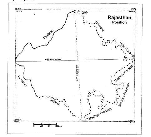
Location and Extent:
- To the North-West of India in the kite-shaped between 23° 3’ to 30° 12’ N, latitude and 69° 30’ to 78° 17’ E longitudes.
- Tropic of Cancer (23°30′ N latitude) passes through southern tip.
- Length 869 km from East to West.
- Breadth 826 km from North to South.
- Total area – 3,42,239 sq km i.e. 10.43% of India, ranks first in term of area in India.
- In the west 1070 km international border with Pakistan, Uttar Pradesh and Madhya Pradesh in East, Punjab and Haryana
- in North and Gujarat and Madhya Pradesh in South.
- Population – as per 2011 Census 6,85,48,437 people live here. Average density-200 persons per sq. km.
Administrative Units of Rajasthan
Unification of Rajasthan was completed in 1956. At present in administrative view, it is divided into 7 zones, 33 districts (244) tehsils. Seven divisions, i.e., Jaipur, Ajmer, Bikaner, Jodhpur, Udaipur, Kota and Bharatpur, each headed by Divisional Commissioner.
Jaisalmer is the largest and Dhaulpur is the smallest districts in terms of area. Names of districts of State are Ajmer, Alwar, Bara, Banswara, Barmer, Bharatpur, Bhilwara, Bikaner, Bundi, Cguttire, Churu, Dhaulpur, Dausa, Doongarpur, Sri Ganganagar, Hanumangarh, Jaipur, Jaisalmer, Jallore, Jhalawar, Jhunjhunu, Jodhpur, Karauli, Kota, Nagaur, Pali, Pratapgarh, Rajsamand, Sawai Madhopur, Sikar, Sirohi, Tonk and Udaipur.
Himadri: Greater Himalayas
Subcontinent: A land surrounded by water
Region: A vast area with similar features
Sand dunes: Mounds of loose sand in desert area
Doab: A land between two rivers