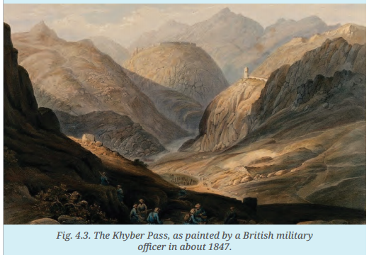
Observe the sketch of the Khyber Pass (Fig. 4.3) (see textbook). What kind of terrain does it depict? Class 7
hardObserve the sketch of the Khyber Pass (Fig. 4.3) (see textbook). What kind of terrain does it depict? Class 7
Question 1.
Observe the sketch of the Khyber Pass (Fig. 4.3) (see textbook). What kind of terrain does it depict? Class 7
Answer:
The image shows a very rough and mountainous terrain. It features steep, rocky cliffs and narrow valleys with winding paths. The ground looks dry and sandy, with very little greenery. It is a high-altitude area that looks difficult to cross.
Question 2.
What advantages would it offer to an army trying to reach the Indus plains? But also, what dangers? Class 7
Answer:
Advantages: The narrow paths act as a natural defence. A small army can easily hide behind rocks to surprise enemies. It also provides a direct, high-ground route for soldiers to reach the fertile Indus plains for conquest.
Dangers: The narrow roads make the army easy to trap or ambush from the cliffs above. There is very little food or water available in the mountains. Soldiers could also slip off the steep edges or get stuck during bad weather.
Question 3.
Thinking of the caravans of traders that passed through the Khyber Pass for many centuries, let's ask the same questions about the advantages as well as dangers. Class 7
Answer:
Advantages: For centuries, this pass was the fastest "shortcut" connecting Central Asia to India. It allowed trâders to move heavy goods like silk and spices through the mountains instead of climbing over the highest, most dangerous peaks.
Dangers: Caravans were slow and carried expensive goods, making them easy targets for robbers or local tribes hiding in the hills. The rocky paths could also injure camels or horses, causing traders to lose their valuable supplies.